Surveying the site of the shipwreck
Mark Adams, Senior Archaeological Project Officer at the Museum of Liverpool's
archaeology department, has been uncovering a mystery hidden by the sand on a nearby beach. He explains:
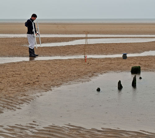
"Last Wednesday and Thursday I swapped the office for Ainsdale Beach to conduct a geophysical and auger survey of a shipwreck off the Ainsdale coast with volunteers from the Sefton Coast Landscape Partnership. The wreck is the remains of a wooden vessel, last seen in the early 1980s before it was exposed again by last winter’s storms. Its date and name are unknown, we didn’t even know basic things like its size because only the stern has ever been seen.
After some basic training the volunteers surveyed the wreck site using a fluxgate gradiometer, essentially a very sensitive metal detector, in an attempt to find out just how big she is. As far as I’ve been able to find out this type of survey has only been done on a beach wreck once before in the UK, so it was nice to work with volunteers on something close to the cutting edge of archaeology. I had no idea whether it would work at all, but first impressions are that it has worked rather well.

The survey of the shipwreck site shows anomalies hidden under the sand.
The plot in the photo shown here is from the raw data and needs to be put onto a base map, but north is at the top and it covers an area of 60 x 60 metres. There are two very large anomalies (the black and white blobs in the centre), one at either end of the wreck. From these it looks like the wreck is about 30 m long and 7-10 m wide and lying NNW-SSE with the stern at the north end. The anomaly at the north east corner of the survey area is presumably general beach debris, I ran a quick scan around it and it doesn’t look like it extends any further to the north or west.
We also ran a couple of transects across the site with a hand auger. That didn’t work so well, generally speaking it only seemed to hit compacted sands at around 1.2-1.3 m deep, though that does at least give the minimum depth of sand cover. There’s no evidence of the sides of the vessel surviving well, so perhaps the vessel has been flattened or compressed by the weight of sand cover, I suspect it’s normally covered by 2-3 m of wet sand.
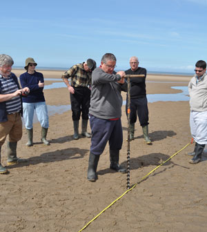
Volunteers using a hand auger to survey the site
The auger may have hit an obstruction relating to the anomaly at the NE end of the wreck at a depth of 1.2 m, I’m not sure, but the depth of sand cover suggests that the anomalies relate to objects which are large and deeply buried rather than small and close to the surface.
Now we know how big the wreck is, which way she lies and how deeply buried, we can start to think of ways of identifying her."

 Surveying the site of the shipwreck
Mark Adams, Senior Archaeological Project Officer at the Museum of Liverpool's archaeology department, has been uncovering a mystery hidden by the sand on a nearby beach. He explains:
"Last Wednesday and Thursday I swapped the office for Ainsdale Beach to conduct a geophysical and auger survey of a shipwreck off the Ainsdale coast with volunteers from the Sefton Coast Landscape Partnership. The wreck is the remains of a wooden vessel, last seen in the early 1980s before it was exposed again by last winter’s storms. Its date and name are unknown, we didn’t even know basic things like its size because only the stern has ever been seen.
After some basic training the volunteers surveyed the wreck site using a fluxgate gradiometer, essentially a very sensitive metal detector, in an attempt to find out just how big she is. As far as I’ve been able to find out this type of survey has only been done on a beach wreck once before in the UK, so it was nice to work with volunteers on something close to the cutting edge of archaeology. I had no idea whether it would work at all, but first impressions are that it has worked rather well.
Surveying the site of the shipwreck
Mark Adams, Senior Archaeological Project Officer at the Museum of Liverpool's archaeology department, has been uncovering a mystery hidden by the sand on a nearby beach. He explains:
"Last Wednesday and Thursday I swapped the office for Ainsdale Beach to conduct a geophysical and auger survey of a shipwreck off the Ainsdale coast with volunteers from the Sefton Coast Landscape Partnership. The wreck is the remains of a wooden vessel, last seen in the early 1980s before it was exposed again by last winter’s storms. Its date and name are unknown, we didn’t even know basic things like its size because only the stern has ever been seen.
After some basic training the volunteers surveyed the wreck site using a fluxgate gradiometer, essentially a very sensitive metal detector, in an attempt to find out just how big she is. As far as I’ve been able to find out this type of survey has only been done on a beach wreck once before in the UK, so it was nice to work with volunteers on something close to the cutting edge of archaeology. I had no idea whether it would work at all, but first impressions are that it has worked rather well.
 The survey of the shipwreck site shows anomalies hidden under the sand.
The plot in the photo shown here is from the raw data and needs to be put onto a base map, but north is at the top and it covers an area of 60 x 60 metres. There are two very large anomalies (the black and white blobs in the centre), one at either end of the wreck. From these it looks like the wreck is about 30 m long and 7-10 m wide and lying NNW-SSE with the stern at the north end. The anomaly at the north east corner of the survey area is presumably general beach debris, I ran a quick scan around it and it doesn’t look like it extends any further to the north or west.
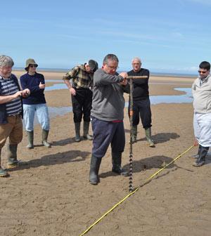
We also ran a couple of transects across the site with a hand auger. That didn’t work so well, generally speaking it only seemed to hit compacted sands at around 1.2-1.3 m deep, though that does at least give the minimum depth of sand cover. There’s no evidence of the sides of the vessel surviving well, so perhaps the vessel has been flattened or compressed by the weight of sand cover, I suspect it’s normally covered by 2-3 m of wet sand.
The survey of the shipwreck site shows anomalies hidden under the sand.
The plot in the photo shown here is from the raw data and needs to be put onto a base map, but north is at the top and it covers an area of 60 x 60 metres. There are two very large anomalies (the black and white blobs in the centre), one at either end of the wreck. From these it looks like the wreck is about 30 m long and 7-10 m wide and lying NNW-SSE with the stern at the north end. The anomaly at the north east corner of the survey area is presumably general beach debris, I ran a quick scan around it and it doesn’t look like it extends any further to the north or west.
We also ran a couple of transects across the site with a hand auger. That didn’t work so well, generally speaking it only seemed to hit compacted sands at around 1.2-1.3 m deep, though that does at least give the minimum depth of sand cover. There’s no evidence of the sides of the vessel surviving well, so perhaps the vessel has been flattened or compressed by the weight of sand cover, I suspect it’s normally covered by 2-3 m of wet sand.
 Volunteers using a hand auger to survey the site
The auger may have hit an obstruction relating to the anomaly at the NE end of the wreck at a depth of 1.2 m, I’m not sure, but the depth of sand cover suggests that the anomalies relate to objects which are large and deeply buried rather than small and close to the surface.
Now we know how big the wreck is, which way she lies and how deeply buried, we can start to think of ways of identifying her."
Volunteers using a hand auger to survey the site
The auger may have hit an obstruction relating to the anomaly at the NE end of the wreck at a depth of 1.2 m, I’m not sure, but the depth of sand cover suggests that the anomalies relate to objects which are large and deeply buried rather than small and close to the surface.
Now we know how big the wreck is, which way she lies and how deeply buried, we can start to think of ways of identifying her."